Archive for 'orientation'
Official city map
Ditch that messy printed map. Now you can have a wrinkle-free map made up of pure recycled electrons, courtesy of Only in San Francisco. Yes, the official city map is available in pdf version, and if you don’t want to print it out you can just turn your laptop upside down to read the reverse (where you will find Larry Flynt’s Hustlers Club among the recommended attractions). San Francisco, open your golden gates!
.
Posted: June 9th, 2008 under orientation.
Comments: none
1938 San Francisco map

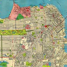
By 1938 the essential outlines of the city were filled in and established. Some names have changed — I didn’t know that Fort Point was called Fort Winfield Scott. The location of Funston Park was called Lobos Square. USF was the San Francisco College of Women. There were “bear cages” in the park, as well as “elk and deer corrals.” And so on.
A large (5800 x 4358 px) image of the map is here.
Posted: January 2nd, 2008 under history, maps, orientation.
Comments: none
SF Neighborhoods: another view

This cool San Francisco neighborhood map is currently sold out from ORK posters, but I assume it will be back in print at some point. It’s much more sophisticated from a graphic design point of view than this version.
The typeface appears to be FF DIN Condensed.
(Note that the map is copyrighted by ORK design and should be purchased from them.)
Posted: December 18th, 2007 under art, maps, orientation.
Comments: none
San Francisco neighborhoods

Dreamworld.org has a good overview of San Francisco neighborhoods, with some comment under the heading “a local’s guide.” Nice identification of SF neighborhoods, although the typography and color scheme would induce migraines. For the screenshot above I mellowed out the colors a bit.
Posted: December 3rd, 2007 under living here, maps, orientation.
Comments: 3
Historical map of San Francisco Creeks
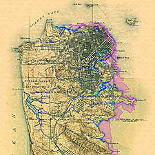
This great map from the 1890s shows creeks in blue and marshes in green, with modern landfill in magenta. A larger version is at the Oakland Museum of California site.

Posted: November 29th, 2007 under history, maps, nature, orientation.
Comments: 2
NOAA coast survey maps
The National Oceanic and Atmospheric Administration has a series of excellent bay maps on the web. Although the NOAA cautions that the maps are not to be used for nautical navigation, they do show depth contours in considerable detail. This section shows the Bay Bridge where a South Korean vessel collided with the bridge, releasing an oil spill whose effects will likely be suffered for years.

The maps can be zoomed and dragged. In the following view I’ve zoomed in a little (but not nearly all the way) to show some of the detail that the maps contain.

As far as I can tell, the site does not as yet have a user-friendly overview page. You kind of have to go to a page — like this one for chart 18650 — and then back up a directory and hunt around — or you could just try entering contiguous numbers in the url. It’s worth the effort if you are planning on being out on the bay or if you have an interest in its shorelines.
Posted: November 12th, 2007 under bay, maps, orientation.
Comments: none
San Francisco cable car lines, 1893
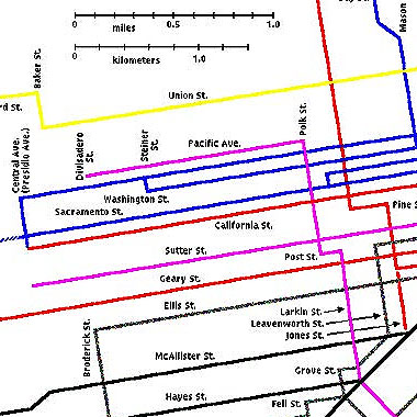
Some people don’t realize that cable cars were at one time a working transit system in San Francisco and not just an amusement ride for tourists. In fact, when I first came to the city I used a cable car for one leg of my commute. The cars cost the same as buses then.
Click on the detail below to see a full map of San Francisco cable car lines in 1893. The original could be better quality. I played with levels and curves to make this detail a bit more legible.
Posted: August 27th, 2007 under history, orientation.
Comments: 3
1907 San Francisco Street Map
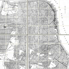
This 1907 street map from the San Francisco History website has great detail. Clicking on the sections of the map at that site enlarges them.
Posted: June 5th, 2007 under history, maps, orientation.
Comments: none
SF Viewer
Although I don’t think it has been much publicized, the city of San Francisco provides a web service called SF Viewer. It provides maps to any address, including options to view satelite photos, street sweeping times, property values, and other information.
Posted: May 22nd, 2007 under orientation.
Comments: 2
Bay Area Maps Online
Bay City Guide has posted a selection of useful Bay Area maps in pdf format.
Included are:
- San Francisco street map
- San Francisco MUNI map
- Bay Area / Northern California map
- Golden Gate Park / Union Square map (interesting concept)
- Fisherman’s Wharf map
- BART map
- Ferry map
Posted: April 16th, 2007 under getting around, maps, orientation.
Comments: none


