Category: maps
By David Enos
For a handy map of canoe and kayak put-in locations around the Bay Area, check out gotoes.org. Happy paddling! .
map by Chronicle Graphics I missed this article when it appeared in the San Francisco Chronicle back in December. It presents several of the city’s neighborhoods from the…
SF Gate provides this cheery map, on which each pin represents a homicide. What a lot of them! Could violent criminals be going into upscale neighborhoods and mowing…
Thinking of buying a house or two in San Francisco? The Trulia real estate prices heat map might be just the thing to help you narrow your search….
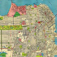
By 1938 the essential outlines of the city were filled in and established. Some names have changed — I didn’t know that Fort Point was called Fort Winfield…
This cool San Francisco neighborhood map is currently sold out from ORK posters, but I assume it will be back in print at some point. It’s much more…
Dreamworld.org has a good overview of San Francisco neighborhoods, with some comment under the heading “a local’s guide.” Nice identification of SF neighborhoods, although the typography and color…
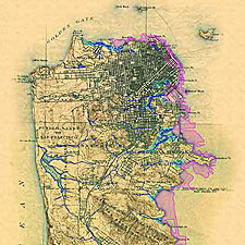
This great map from the 1890s shows creeks in blue and marshes in green, with modern landfill in magenta. A larger version is at the Oakland Museum of…
The National Oceanic and Atmospheric Administration has a series of excellent bay maps on the web. Although the NOAA cautions that the maps are not to be used…
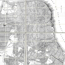
This 1907 street map from the San Francisco History website has great detail. Clicking on the sections of the map at that site enlarges them.
Bay City Guide has posted a selection of useful Bay Area maps in pdf format. Included are: San Francisco street map San Francisco MUNI map Bay Area /…